Cambridge Chalk Streams
20.3 km (12.6 Miles)
Time: 4 hrs 15 mins
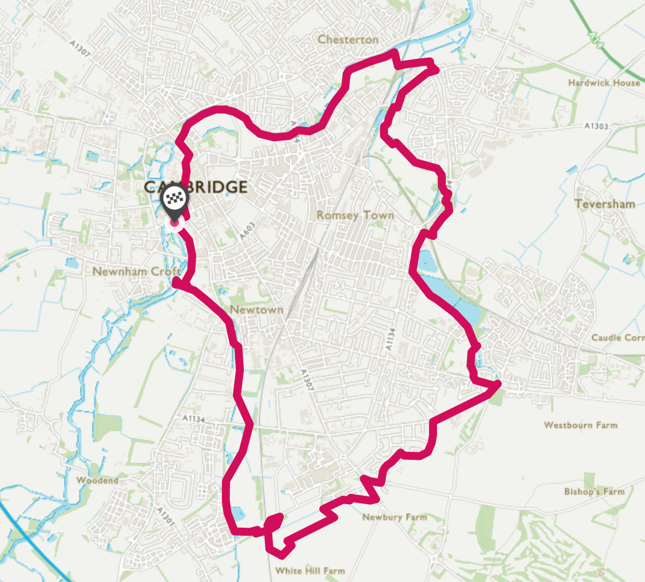
This lovely walk follows the two major chalk streams, Hobson’s/Vicars Brook and Cherry Hinton Brook, which have provided Cambridge with a fresh water supply over the centuries. Both Brooks are followed for their entire length.
Directions
Section 1
The Mill to Hodson’s Folly 1km
Our walk begins at The Mill Pub, next to the Mill Pond (1) at the end of Mill Lane.
(1) Mill Pond
Facing The Mill pub, turn right and follow Granta Place, past the hotel on your right and then onto the footpath across Coe Fen.
Follow the path across Coe Fen keeping the ditch on your right.
Cross Fen Causeway and continue ahead.
At a fork in the path. Vicar’s Brook is immediately in front of you.
Turn right and through the arch to the left of the footbridge, to enter, Hodson’s Folly.
At the southern end of the folly is an inlet where Vicar’s Brook enters the Cam. (2)

(2) Vicar’s Brook at Hodson’s Folly, where it meets The Cam
Section 2
Hobson’s/Vicars Brook 4.9km
Come back out of the folly and follow the path across Coe Fen, walking alongside the brook(on your right) (3) until you reach the road at the Trumpington Road/ Brooklands Avenue junction.
(3) Vicar’s Brook at Trumpington Road

Cross over and walk a short way along Brooklands Avenue before descending the steps on the right hand side, which brings you alongside Hobson’s conduit. signposted for Long Road
(4) Steps off Brooklands Avenue
Follow the wooded path keeping the brook on your left. This is a lovely stretch of urban countryside, where you can see a surprising amount of wildlife.
Eventually, the path crosses a small brick bridge onto an open meadow. (5)
(5) Bridge crossing Hobson’s Brook
Cross this field diagonally to reach Long Road, where it crosses the guided busway.
At the bridge, go underneath The road bridge and follow the guided busway footpath/cycle way past the playing fields.
After about 1 km, there is a left turn heading for Addenbrookes Hospital. Just past this turn, enter Hobson’s Park to your left (6)

(6) Entrance to Hobson’s Park
Keep to the right hand side of the park and you will soon meet up again with the brook on your right.
Follow the brook through the park.
Just after the blue footbridge, cross the brook and follow the path between the Brook and the houses.

At the end of the park, cross the road and follow the track alongside the Brook (7)

Just before the railway line, turn left under the bridge. (8)
Go up onto and over the bridge. At the roundabout take the first left back towards the railway line, then under the bridge to pick up the track heading towards Shelford.
Keep on the track as it turns left for the woods, which is Nine Wells nature reserve.
Cross the footbridge into the reserve and take some time to explore where a series of springs emerge feeding Hobsons Brook, that has supplied the City of Cambridge with fresh water for centuries.(9) (10)
*NB if you do not want to complete the whole walk, retrace your steps back to The Mill (11.8 km out and back)
(9) Nine Wells Nature Reserve
(10) Monument to the funders of Hobson’s Conduit
Section 3
Nine Wells to Giants Grave. 4.1km
Exit at the far end (left hand gate) of the reserve and follow the path eastwards (right). There are two parallel paths here. One between two high hedges, and one to its right, which follows the field boundary. Either of these are fine.
At the end of the hedges take a sharp left towards the new housing estate.
At the end of this path, turn right either following the field edge path, or the parallel surfaced cycle route, just inside the housing development.

These eventually join into the cycle track, (11) which you should follow to reach Babraham Road.
Cross over and turn left here, then right along Wort’s Causeway.
From here, the next part is on a series of suburban roads. Follow, Fields Way, Bowers Croft ( left fork) taking the path through to Almoner’s Avenue and then right onto Beaumont Road, all the way to Queen Edith’s Way.
Turn right along Queen Edith’s Way and follow until you reach the Junction (Robin Hood) with Cherry Hinton Road.
Cross straight over the junction and immediately on your left you will see a slope with a pool at the bottom. This is locally known as the Giants Grave and is the source of Cherry Hinton Brook. (12)
(12) Giants Grave
Section 4
Giants Grave to Stourbridge Common 5.9km
Leave Giants Grave and follow Cherry Hinton Road towards Cambridge. You will shortly reach Cherry Hinton Hall Park. Use the first entrance and follow the path until you reach the ponds and weir. (13) (14)

(13) Lost Watermills

(14) Cherry Hinton Park
It is believed that historically there have been a number of mills located along this section of the brook.
Follow the Brook out of the Park and onto ‘Snakey Path’
Follow ‘Snakey Path’ and along the brook crossing to the left hand bank (15) and follow the path onto Burnside.

(15) Crossing the Brook
At the end of Burnside, keep following the path beside the brook (16) to reach Sainsbury’s. (A potential refuelling and toilet stop)
(16) Path at the end of Burnside
Walk through the car park and exit to the right hand side of the petrol station.
Turn right on Coldhams Lane, under the bridge, then left into Nuttings Road.

At the end of this Cul de Sac, there is a gate into East Barnwell Nature Reserve (17)
Follow the path through the reserve, keep the pond on your right and exit onto Barnwell Road
Cross this road turn right and then first left on a road leading to Coldhams Common.
Once through the barrier, (18) turn right and follow the path through the woods.
Here you rejoin the brook and follow downstream until you reach the Car Park at the Abbey Sports Centre.
Go through the Car Park, turn left over the bridge then right, keeping the ‘all weather’ pitches to your left.
Cross the brook again using the bridge and follow the path. Bear right when you meet the surfaced path, walking alongside Cambridge United Football Club.
At Newmarket Road, you may want to make a short detour (50m left) to visit the Leper Chapel, the oldest building in Cambridge, dating from 1125AD.
The main route turns right and then left into Ditton Walk. Follow this for 500m through the bollards then left onto a footpath, leaving the road as it bends right.
Shortly along this path is a gap and footpath to the left with two wooden bollards at its entrance (19). Take this to reach the open space of Ditton Meadows.

(19) Entrance to Ditton Meadows
Turn left to follow a faint path and over the footbridge at a gap in the hedge. (This area can be very boggy at certain times of the year)
Once through, head left to cross the brook on a walkway and climb the footbridge over the main Cambridge to Kings Lynn railway line, reaching Stourbridge Common, famous for its ancient Stourbridge Fair.
On the other side, turn right to reach the River Cam

The Brook meets the Cam just after it flows under the foot/cycle bridge on your right hand side (20)

(21) footbridge
Section 5
Stourbridge Common to the Mill Pond. 4.4km
The final section is straightforward and takes you along the river Cam to the centre of Cambridge
Follow the path upstream along the river for 3.3km. This will take you through, in order, Stourbridge Common, Riverside, Midsummer Common and Jesus Green.
Finish by following the wooden walkway alongside the Cam at the far end of Jesus Green just past the Tennis Courts.
When you get to Magdalene Bridge, (22) turn left along bridge street and the right into Trinity Street.
(22) Magdalene Bridge
Pass numerous colleges, including St John’s, Trinity, Gonville and Caius,
then continue straight on as the road becomes King’s Parade, past The Senate House (23), King’s College (24) and the Corpus Clock on your left.
(23) Senate House
(24) Kings College Chapel
Here the road becomes Trumpington Street. Continue past Corpus Christi and St Catherine’s Colleges.
At the junction, continue a little along Trumpington Street. At Fitzbillies Café (try their Chelsea Buns), turn right and follow Mill Lane until you reach the end of the walk at The Mill.